
Magnitude 4.6 - SUNDA STRAIT, INDONESIA
2012 January 18 21:16:25 UTC
Earthquake Details
- This event has been reviewed by a seismologist.
| Magnitude | 4.6 |
|---|---|
| Date-Time |
|
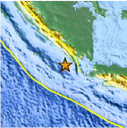
| Location | 6.097°S, 104.066°E |
| Depth | 12.4 km (7.7 miles) |
| Region | SUNDA STRAIT, INDONESIA |
| Distances | 150 km (93 miles) WSW of T.-Telukbetung, Sumatra, Indonesia 219 km (136 miles) W of Cilegon, Java, Indonesia 295 km (183 miles) S of Perabumulih, Sumatra, Indonesia 305 km (189 miles) W of JAKARTA, Java, Indonesia |
| Location Uncertainty | horizontal +/- 36.5 km (22.7 miles); depth +/- 7 km (4.3 miles) |
| Parameters | NST= 31, Nph= 31, Dmin=228.2 km, Rmss=1.32 sec, Gp=176°, M-type=body wave magnitude (Mb), Version=8 |
| Source |
|
| Event ID | usc0007n7d |
- Did you feel it? Report shaking and damage at your location. You can also view a map displaying accumulated data from your report and others.

Earthquake Maps


Scientific & Technical Information
 Historic Moment Tensor Solutions
- Preliminary Earthquake Report
- U.S. Geological Survey, National Earthquake Information Center:
World Data Center for Seismology, Denver
