
Magnitude 4.6 - FIJI REGION
2012 January 17 10:10:01 UTC
Earthquake Details
- This event has been reviewed by a seismologist.
| Magnitude | 4.6 |
|---|---|
| Date-Time |
|
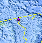
| Location | 15.665°S, 177.474°W |
| Depth | 382.6 km (237.7 miles) |
| Region | FIJI REGION |
| Distances | 169 km (105 miles) SSE of Sigave, Ile Futuna, Wallis and Futuna 300 km (186 miles) SSW of MATA'UTU, Ile Uvea, Wallis and Futuna 346 km (214 miles) ENE of Lambasa, Vanua Levu, Fiji 2471 km (1535 miles) NNE of Auckland, New Zealand |
| Location Uncertainty | horizontal +/- 24.3 km (15.1 miles); depth +/- 12.8 km (8.0 miles) |
| Parameters | NST=148, Nph=149, Dmin=643.4 km, Rmss=0.79 sec, Gp=112°, M-type=body wave magnitude (Mb), Version=7 |
| Source |
|
| Event ID | usc0007m3p |
- Did you feel it? Report shaking and damage at your location. You can also view a map displaying accumulated data from your report and others.
Earthquake Maps


Scientific & Technical Information
 Historic Moment Tensor Solutions
- Preliminary Earthquake Report
- U.S. Geological Survey, National Earthquake Information Center:
World Data Center for Seismology, Denver
