
Magnitude 4.9 - MARIANA ISLANDS REGION
2012 January 17 09:38:14 UTC
Earthquake Details
- This event has been reviewed by a seismologist.
| Magnitude | 4.9 |
|---|---|
| Date-Time |
|
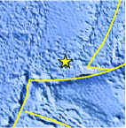
| Location | 12.149°N, 141.162°E |
| Depth | 63.4 km (39.4 miles) |
| Region | MARIANA ISLANDS REGION |
| Distances | 416 km (258 miles) WSW of HAGATNA, Guam 441 km (274 miles) NE of Yap, Micronesia 491 km (305 miles) WSW of Rota, Northern Mariana Islands 597 km (370 miles) SW of SAIPAN, Northern Mariana Islands |
| Location Uncertainty | horizontal +/- 20.7 km (12.9 miles); depth +/- 11.2 km (7.0 miles) |
| Parameters | NST= 46, Nph= 48, Dmin=433 km, Rmss=0.8 sec, Gp= 86°, M-type=body wave magnitude (Mb), Version=5 |
| Source |
|
| Event ID | usc0007m37 |
- Did you feel it? Report shaking and damage at your location. You can also view a map displaying accumulated data from your report and others.
Earthquake Maps


Scientific & Technical Information
 Historic Moment Tensor Solutions
- Preliminary Earthquake Report
- U.S. Geological Survey, National Earthquake Information Center:
World Data Center for Seismology, Denver
