
Magnitude 4.9 - NEAR THE SOUTH COAST OF PAPUA, INDONESIA
2012 January 17 09:23:18 UTC
Earthquake Details
- This event has been reviewed by a seismologist.
| Magnitude | 4.9 |
|---|---|
| Date-Time |
|
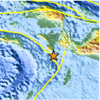
| Location | 4.479°S, 133.290°E |
| Depth | 9.7 km (6.0 miles) |
| Region | NEAR THE SOUTH COAST OF PAPUA, INDONESIA |
| Distances | 175 km (108 miles) NW of Dobo, Kepulauan Aru, Indonesia 348 km (216 miles) W of Enarotali, Papua, Indonesia 409 km (254 miles) SSW of Manokwari, Papua, Indonesia 923 km (573 miles) NNE of DARWIN, Northern Territory, Australia |
| Location Uncertainty | horizontal +/- 26 km (16.2 miles); depth +/- 8.7 km (5.4 miles) |
| Parameters | NST= 37, Nph= 37, Dmin=208.2 km, Rmss=1.16 sec, Gp= 86°, M-type=body wave magnitude (Mb), Version=8 |
| Source |
|
| Event ID | usc0007m2q |
- Did you feel it? Report shaking and damage at your location. You can also view a map displaying accumulated data from your report and others.

Earthquake Maps


Scientific & Technical Information
 Historic Moment Tensor Solutions
- Preliminary Earthquake Report
- U.S. Geological Survey, National Earthquake Information Center:
World Data Center for Seismology, Denver
