
Magnitude 4.3 - OFF WEST COAST OF THE SOUTH ISLAND, N.Z.
2012 January 17 07:40:29 UTC
Earthquake Details
- This event has been reviewed by a seismologist.
| Magnitude | 4.3 |
|---|---|
| Date-Time |
|
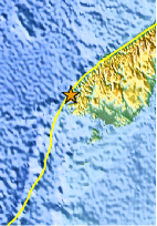
| Location | 45.536°S, 166.615°E |
| Depth | 5 km (3.1 miles) (poorly constrained) |
| Region | OFF WEST COAST OF THE SOUTH ISLAND, N.Z. |
| Distances | 165 km (102 miles) NW of Invercargill, New Zealand 170 km (105 miles) WSW of Queenstown, New Zealand 306 km (190 miles) W of Dunedin, New Zealand 811 km (503 miles) SW of WELLINGTON, New Zealand |
| Location Uncertainty | horizontal +/- 26.7 km (16.6 miles); depth +/- 6.9 km (4.3 miles) |
| Parameters | Nph= 0, Dmin=0 km, Rmss=0.7 sec, Gp= 0, M-type=body wave magnitude (Mb), Version=5 |
| Source |
|
| Event ID | usc0007m1x |
- Did you feel it? Report shaking and damage at your location. You can also view a map displaying accumulated data from your report and others.
Earthquake Maps


Scientific & Technical Information
 Historic Moment Tensor Solutions
- Preliminary Earthquake Report
- U.S. Geological Survey, National Earthquake Information Center:
World Data Center for Seismology, Denver
