
Magnitude 4.9 - TONGA REGION
2012 January 16 18:39:54 UTC
Earthquake Details
- This event has been reviewed by a seismologist.
| Magnitude | 4.9 |
|---|---|
| Date-Time |
|
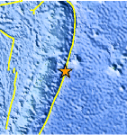
| Location | 19.292°S, 172.897°W |
| Depth | 28.8 km (17.9 miles) |
| Region | TONGA REGION |
| Distances | 134 km (83 miles) ESE of Neiafu, Tonga 315 km (195 miles) NE of NUKU`ALOFA, Tonga 320 km (198 miles) W of Niue Island 2289 km (1422 miles) NE of Auckland, New Zealand |
| Location Uncertainty | horizontal +/- 23.3 km (14.5 miles); depth +/- 6.4 km (4.0 miles) |
| Parameters | NST= 71, Nph= 71, Dmin=607.8 km, Rmss=1.21 sec, Gp= 79°, M-type=body wave magnitude (Mb), Version=5 |
| Source |
|
| Event ID | usc0007lt1 |
- Did you feel it? Report shaking and damage at your location. You can also view a map displaying accumulated data from your report and others.
Earthquake Maps


Scientific & Technical Information
 Historic Moment Tensor Solutions
- Preliminary Earthquake Report
- U.S. Geological Survey, National Earthquake Information Center:
World Data Center for Seismology, Denver
