
Magnitude 4.5 - JAVA, INDONESIA
2012 January 14 11:55:20 UTC
Earthquake Details
- This event has been reviewed by a seismologist.
| Magnitude | 4.5 |
|---|---|
| Date-Time |
|
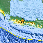
| Location | 6.896°S, 108.167°E |
| Depth | 17.8 km (11.1 miles) |
| Region | JAVA, INDONESIA |
| Distances | 47 km (29 miles) N of Tasikmalaya, Java, Indonesia 47 km (29 miles) WSW of Cirebon, Java, Indonesia 60 km (37 miles) E of Bandung, Java, Indonesia 169 km (105 miles) ESE of JAKARTA, Java, Indonesia |
| Location Uncertainty | horizontal +/- 15.4 km (9.6 miles); depth +/- 8.7 km (5.4 miles) |
| Parameters | NST= 20, Nph= 22, Dmin=82.4 km, Rmss=1 sec, Gp=101°, M-type=body wave magnitude (Mb), Version=8 |
| Source |
|
| Event ID | usc0007ks5 |
- Did you feel it? Report shaking and damage at your location. You can also view a map displaying accumulated data from your report and others.

Earthquake Maps


Scientific & Technical Information
 Historic Moment Tensor Solutions
- Preliminary Earthquake Report
- U.S. Geological Survey, National Earthquake Information Center:
World Data Center for Seismology, Denver
