
Magnitude 5.4 - TONGA
2012 January 12 22:31:00 UTC
Earthquake Details
- This event has been reviewed by a seismologist.
| Magnitude | 5.4 |
|---|---|
| Date-Time |
|
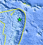
| Location | 16.528°S, 173.391°W |
| Depth | 79.5 km (49.4 miles) |
| Region | TONGA |
| Distances | 74 km (45 miles) SSE of Hihifo, Tonga 242 km (150 miles) NNE of Neiafu, Tonga 347 km (215 miles) SSW of APIA, Samoa 2538 km (1577 miles) NNE of Auckland, New Zealand |
| Location Uncertainty | horizontal +/- 16.1 km (10.0 miles); depth +/- 13.1 km (8.1 miles) |
| Parameters | NST= 84, Nph= 84, Dmin=337.3 km, Rmss=1.27 sec, Gp= 65°, M-type=body wave magnitude (Mb), Version=7 |
| Source |
|
| Event ID | usc0007jyx |
- Did you feel it? Report shaking and damage at your location. You can also view a map displaying accumulated data from your report and others.
Earthquake Maps


Scientific & Technical Information
 Historic Moment Tensor Solutions
 Tsunami Information
The earthquake locations and magnitudes cited in NOAA tsunami statements and bulletins are preliminary and are superseded by USGS locations and magnitudes computed using more extensive data sets.
General Tsunami Information
- Preliminary Earthquake Report
- U.S. Geological Survey, National Earthquake Information Center:
World Data Center for Seismology, Denver
