
Magnitude 4.5 - KEPULAUAN MENTAWAI REGION, INDONESIA
2012 January 11 11:36:19 UTC
Earthquake Details
- This event has been reviewed by a seismologist.
| Magnitude | 4.5 |
|---|---|
| Date-Time |
|
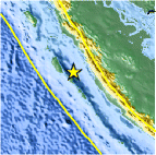
| Location | 1.737°S, 99.758°E |
| Depth | 33.4 km (20.8 miles) |
| Region | KEPULAUAN MENTAWAI REGION, INDONESIA |
| Distances | 109 km (67 miles) SW of Padang, Sumatra, Indonesia 313 km (194 miles) SW of Pekanbaru, Sumatra, Indonesia 565 km (351 miles) SW of SINGAPORE 925 km (574 miles) WNW of JAKARTA, Java, Indonesia |
| Location Uncertainty | horizontal +/- 28.3 km (17.6 miles); depth +/- 6.9 km (4.3 miles) |
| Parameters | NST= 24, Nph= 25, Dmin=269.4 km, Rmss=0.63 sec, Gp=194°, M-type=body wave magnitude (Mb), Version=3 |
| Source |
|
| Event ID | usc0007j57 |
- Did you feel it? Report shaking and damage at your location. You can also view a map displaying accumulated data from your report and others.

Earthquake Maps


Scientific & Technical Information
 Historic Moment Tensor Solutions
- Preliminary Earthquake Report
- U.S. Geological Survey, National Earthquake Information Center:
World Data Center for Seismology, Denver
