
Magnitude 4.9 - VANUATU
2012 January 11 03:29:38 UTC
Earthquake Details
- This event has been reviewed by a seismologist.
| Magnitude | 4.9 |
|---|---|
| Date-Time |
|
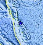
| Location | 17.156°S, 168.800°E |
| Depth | 218.5 km (135.8 miles) |
| Region | VANUATU |
| Distances | 81 km (50 miles) NE of PORT-VILA, Efate, Vanuatu 250 km (155 miles) SE of Luganville, Espiritu Santo, Vanuatu 269 km (167 miles) N of Isangel, Tanna, Vanuatu 1985 km (1233 miles) ENE of BRISBANE, Queensland, Australia |
| Location Uncertainty | horizontal +/- 19.6 km (12.2 miles); depth +/- 16.3 km (10.1 miles) |
| Parameters | NST= 28, Nph= 29, Dmin=597.8 km, Rmss=0.84 sec, Gp=130°, M-type=body wave magnitude (Mb), Version=5 |
| Source |
|
| Event ID | usc0007j0x |
- Did you feel it? Report shaking and damage at your location. You can also view a map displaying accumulated data from your report and others.
Earthquake Maps


Scientific & Technical Information
 Historic Moment Tensor Solutions
- Preliminary Earthquake Report
- U.S. Geological Survey, National Earthquake Information Center:
World Data Center for Seismology, Denver
