
Magnitude 4.7 - EAST TIMOR REGION
2012 January 11 00:20:21 UTC
Earthquake Details
- This event has been reviewed by a seismologist.
| Magnitude | 4.7 |
|---|---|
| Date-Time |
|
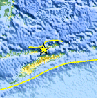
| Location | 8.073°S, 125.574°E |
| Depth | 41.1 km (25.5 miles) |
| Region | EAST TIMOR REGION |
| Distances | 54 km (33 miles) N of DILI, Timor-Leste 318 km (197 miles) NE of Kupang, Timor, Indonesia 436 km (270 miles) SE of Baubau, Sulawesi, Indonesia 754 km (468 miles) NW of DARWIN, Northern Territory, Australia |
| Location Uncertainty | horizontal +/- 17.8 km (11.1 miles); depth +/- 10.6 km (6.6 miles) |
| Parameters | NST= 33, Nph= 34, Dmin=234.9 km, Rmss=0.71 sec, Gp= 43°, M-type=body wave magnitude (Mb), Version=4 |
| Source |
|
| Event ID | usc0007izz |
- Did you feel it? Report shaking and damage at your location. You can also view a map displaying accumulated data from your report and others.

Earthquake Maps


Scientific & Technical Information
 Historic Moment Tensor Solutions
- Preliminary Earthquake Report
- U.S. Geological Survey, National Earthquake Information Center:
World Data Center for Seismology, Denver
