
Magnitude 4.8 - HALMAHERA, INDONESIA
2012 January 08 23:45:19 UTC
Earthquake Details
- This event has been reviewed by a seismologist.
| Magnitude | 4.8 |
|---|---|
| Date-Time |
|
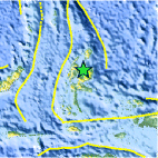
| Location | 1.453°N, 128.212°E |
| Depth | 86.9 km (54.0 miles) |
| Region | HALMAHERA, INDONESIA |
| Distances | 117 km (72 miles) NE of Ternate, Moluccas, Indonesia 374 km (232 miles) E of Manado, Sulawesi, Indonesia 954 km (592 miles) SW of KOROR, Palau 1658 km (1030 miles) SSE of MANILA, Philippines |
| Location Uncertainty | horizontal +/- 16.7 km (10.4 miles); depth +/- 12.3 km (7.6 miles) |
| Parameters | NST= 43, Nph= 43, Dmin=120.2 km, Rmss=0.65 sec, Gp= 43°, M-type=body wave magnitude (Mb), Version=5 |
| Source |
|
| Event ID | usc0007hqh |
- Did you feel it? Report shaking and damage at your location. You can also view a map displaying accumulated data from your report and others.

Earthquake Maps


Scientific & Technical Information
 Historic Moment Tensor Solutions
- Preliminary Earthquake Report
- U.S. Geological Survey, National Earthquake Information Center:
World Data Center for Seismology, Denver
