
Magnitude 5.5 - KERMADEC ISLANDS REGION
2012 January 07 18:37:59 UTC
Earthquake Details
- This event has been reviewed by a seismologist.
| Magnitude | 5.5 |
|---|---|
| Date-Time |
|
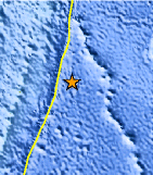
| Location | 28.854°S, 175.255°W |
| Depth | 20.3 km (12.6 miles) |
| Region | KERMADEC ISLANDS REGION |
| Distances | 262 km (162 miles) E of Raoul Island, Kermadec Islands 453 km (281 miles) NE of L'Esperance Rock, Kermadec Islands 854 km (530 miles) S of NUKU`ALOFA, Tonga 1288 km (800 miles) NE of Auckland, New Zealand |
| Location Uncertainty | horizontal +/- 27.2 km (16.9 miles); depth +/- 14.5 km (9.0 miles) |
| Parameters | NST= 41, Nph= 42, Dmin=263.8 km, Rmss=1.07 sec, Gp=184°, M-type=body wave magnitude (Mb), Version=7 |
| Source |
|
| Event ID | usc0007hbr |
- Did you feel it? Report shaking and damage at your location. You can also view a map displaying accumulated data from your report and others.
Earthquake Maps


Scientific & Technical Information

 Tsunami Information
The earthquake locations and magnitudes cited in NOAA tsunami statements and bulletins are preliminary and are superseded by USGS locations and magnitudes computed using more extensive data sets.
General Tsunami Information
- Preliminary Earthquake Report
- U.S. Geological Survey, National Earthquake Information Center:
World Data Center for Seismology, Denver
