
Magnitude 5.6 - HALMAHERA, INDONESIA
2012 January 07 07:31:44 UTC
Earthquake Details
- This event has been reviewed by a seismologist.
| Magnitude | 5.6 |
|---|---|
| Date-Time |
|
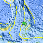
| Location | 1.697°N, 127.433°E |
| Depth | 131.6 km (81.8 miles) |
| Region | HALMAHERA, INDONESIA |
| Distances | 101 km (62 miles) N of Ternate, Moluccas, Indonesia 288 km (178 miles) E of Manado, Sulawesi, Indonesia 1001 km (621 miles) SW of KOROR, Palau 1594 km (990 miles) SSE of MANILA, Philippines |
| Location Uncertainty | horizontal +/- 16.2 km (10.1 miles); depth +/- 8.7 km (5.4 miles) |
| Parameters | NST= 88, Nph= 92, Dmin=102.4 km, Rmss=0.71 sec, Gp= 94°, M-type=body wave magnitude (Mb), Version=B |
| Source |
|
| Event ID | usc0007h84 |
- Did you feel it? Report shaking and damage at your location. You can also view a map displaying accumulated data from your report and others.

Earthquake Maps


Scientific & Technical Information

 Tsunami Information
The earthquake locations and magnitudes cited in NOAA tsunami statements and bulletins are preliminary and are superseded by USGS locations and magnitudes computed using more extensive data sets.
General Tsunami Information
- Preliminary Earthquake Report
- U.S. Geological Survey, National Earthquake Information Center:
World Data Center for Seismology, Denver
