
Magnitude 4.6 - NEW BRITAIN REGION, PAPUA NEW GUINEA
2012 January 06 13:01:33 UTC
Earthquake Details
- This event has been reviewed by a seismologist.
| Magnitude | 4.6 |
|---|---|
| Date-Time |
|
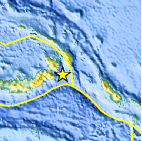
| Location | 5.272°S, 152.538°E |
| Depth | 35.2 km (21.9 miles) |
| Region | NEW BRITAIN REGION, PAPUA NEW GUINEA |
| Distances | 104 km (64 miles) SSW of Taron, New Ireland, PNG 124 km (77 miles) SSE of Rabaul, New Britain, PNG 750 km (466 miles) NE of PORT MORESBY, Papua New Guinea 2461 km (1529 miles) N of BRISBANE, Queensland, Australia |
| Location Uncertainty | horizontal +/- 26.8 km (16.7 miles); depth +/- 8.1 km (5.0 miles) |
| Parameters | NST= 26, Nph= 27, Dmin=126.9 km, Rmss=1.04 sec, Gp= 97°, M-type=body wave magnitude (Mb), Version=5 |
| Source |
|
| Event ID | usc0007gxm |
- Did you feel it? Report shaking and damage at your location. You can also view a map displaying accumulated data from your report and others.

Earthquake Maps


Scientific & Technical Information
 Historic Moment Tensor Solutions
- Preliminary Earthquake Report
- U.S. Geological Survey, National Earthquake Information Center:
World Data Center for Seismology, Denver
