
Magnitude 4.5 - SOUTH ISLAND OF NEW ZEALAND
2012 January 06 12:21:35 UTC
Earthquake Details
- This event has been reviewed by a seismologist.
| Magnitude | 4.5 |
|---|---|
| Date-Time |
|
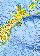
| Location | 43.547°S, 172.982°E |
| Depth | 9.9 km (6.2 miles) |
| Region | SOUTH ISLAND OF NEW ZEALAND |
| Distances | 25 km (15 miles) E of Christchurch, New Zealand 229 km (142 miles) SSE of Westport, New Zealand 290 km (180 miles) SSW of WELLINGTON, New Zealand 324 km (201 miles) NE of Dunedin, New Zealand |
| Location Uncertainty | horizontal +/- 12.1 km (7.5 miles); depth +/- 4.6 km (2.9 miles) |
| Parameters | NST= 34, Nph= 36, Dmin=28.9 km, Rmss=0.84 sec, Gp=140°, M-type=body wave magnitude (Mb), Version=9 |
| Source |
|
| Event ID | usc0007gxd |
- Did you feel it? Report shaking and damage at your location. You can also view a map displaying accumulated data from your report and others.

Earthquake Maps


Scientific & Technical Information

Additional Information
- Preliminary Earthquake Report
- U.S. Geological Survey, National Earthquake Information Center:
World Data Center for Seismology, Denver
