
Magnitude 4.8 - NEW IRELAND REGION, PAPUA NEW GUINEA
2012 January 06 04:31:14 UTC
Earthquake Details
- This event has been reviewed by a seismologist.
| Magnitude | 4.8 |
|---|---|
| Date-Time |
|
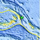
| Location | 4.515°S, 153.368°E |
| Depth | 80.4 km (50.0 miles) |
| Region | NEW IRELAND REGION, PAPUA NEW GUINEA |
| Distances | 37 km (22 miles) E of Taron, New Ireland, PNG 136 km (84 miles) ESE of Rabaul, New Britain, PNG 874 km (543 miles) NE of PORT MORESBY, Papua New Guinea 2544 km (1580 miles) N of BRISBANE, Queensland, Australia |
| Location Uncertainty | horizontal +/- 16.3 km (10.1 miles); depth +/- 8.1 km (5.0 miles) |
| Parameters | NST= 66, Nph= 70, Dmin=138 km, Rmss=1.03 sec, Gp= 90°, M-type=body wave magnitude (Mb), Version=2 |
| Source |
|
| Event ID | usc0007gvx |
- Did you feel it? Report shaking and damage at your location. You can also view a map displaying accumulated data from your report and others.

Earthquake Maps


Scientific & Technical Information
 Historic Moment Tensor Solutions
- Preliminary Earthquake Report
- U.S. Geological Survey, National Earthquake Information Center:
World Data Center for Seismology, Denver
