
Magnitude 5.1 - KEPULAUAN BATU, INDONESIA
2012 January 05 23:14:48 UTC
Earthquake Details
- This event has been reviewed by a seismologist.
| Magnitude | 5.1 |
|---|---|
| Date-Time |
|
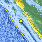
| Location | 0.982°S, 98.985°E |
| Depth | 38.3 km (23.8 miles) |
| Region | KEPULAUAN BATU, INDONESIA |
| Distances | 151 km (93 miles) W of Padang, Sumatra, Indonesia 262 km (162 miles) S of Padangsidempuan, Sumatra, Indonesia 548 km (340 miles) SSW of KUALA LUMPUR, Malaysia 1043 km (648 miles) WNW of JAKARTA, Java, Indonesia |
| Location Uncertainty | horizontal +/- 15.7 km (9.8 miles); depth +/- 11.1 km (6.9 miles) |
| Parameters | NST= 75, Nph= 77, Dmin=270.5 km, Rmss=0.78 sec, Gp= 50°, M-type=body wave magnitude (Mb), Version=7 |
| Source |
|
| Event ID | usc0007grh |
- Did you feel it? Report shaking and damage at your location. You can also view a map displaying accumulated data from your report and others.

Earthquake Maps


Scientific & Technical Information
 Historic Moment Tensor Solutions
 Tsunami Information
The earthquake locations and magnitudes cited in NOAA tsunami statements and bulletins are preliminary and are superseded by USGS locations and magnitudes computed using more extensive data sets.
General Tsunami Information
- Preliminary Earthquake Report
- U.S. Geological Survey, National Earthquake Information Center:
World Data Center for Seismology, Denver
