
Magnitude 4.7 - NEAR NORTH COAST OF NEW GUINEA, P.N.G.
2012 January 04 18:14:24 UTC
Earthquake Details
- This event has been reviewed by a seismologist.
| Magnitude | 4.7 |
|---|---|
| Date-Time |
|
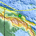
| Location | 4.514°S, 144.414°E |
| Depth | 122.5 km (76.1 miles) |
| Region | NEAR NORTH COAST OF NEW GUINEA, P.N.G. |
| Distances | 136 km (84 miles) SE of Wewak, New Guinea, PNG 151 km (93 miles) N of Mount Hagen, New Guinea, PNG 628 km (390 miles) NNW of PORT MORESBY, Papua New Guinea 2703 km (1679 miles) NNW of BRISBANE, Queensland, Australia |
| Location Uncertainty | horizontal +/- 21.4 km (13.3 miles); depth +/- 11.7 km (7.3 miles) |
| Parameters | NST= 35, Nph= 41, Dmin=427.5 km, Rmss=1.17 sec, Gp= 58°, M-type=body wave magnitude (Mb), Version=5 |
| Source |
|
| Event ID | usc0007g66 |
- Did you feel it? Report shaking and damage at your location. You can also view a map displaying accumulated data from your report and others.

Earthquake Maps


Scientific & Technical Information
 Historic Moment Tensor Solutions
- Preliminary Earthquake Report
- U.S. Geological Survey, National Earthquake Information Center:
World Data Center for Seismology, Denver
