
Magnitude 4.7 - VANUATU
2011 November 30 10:14:05 UTC
Earthquake Details
- This event has been reviewed by a seismologist.
| Magnitude | 4.7 |
|---|---|
| Date-Time |
|
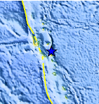
| Location | 15.977°S, 168.137°E |
| Depth | 264.7 km (164.5 miles) |
| Region | VANUATU |
| Distances | 115 km (71 miles) ESE of Luganville, Espiritu Santo, Vanuatu 194 km (120 miles) N of PORT-VILA, Efate, Vanuatu 412 km (256 miles) NNW of Isangel, Tanna, Vanuatu 2015 km (1252 miles) NE of BRISBANE, Queensland, Australia |
| Location Uncertainty | horizontal +/- 20.2 km (12.6 miles); depth +/- 14.8 km (9.2 miles) |
| Parameters | NST= 25, Nph= 26, Dmin=698 km, Rmss=0.74 sec, Gp= 94°, M-type=body wave magnitude (Mb), Version=5 |
| Source |
|
| Event ID | usc0006zrf |
- Did you feel it? Report shaking and damage at your location. You can also view a map displaying accumulated data from your report and others.
Earthquake Maps


Scientific & Technical Information
 Historic Moment Tensor Solutions
- Preliminary Earthquake Report
- U.S. Geological Survey, National Earthquake Information Center:
World Data Center for Seismology, Denver
