
Magnitude 4.8 - FIJI REGION
2011 November 29 23:44:29 UTC
Earthquake Details
- This event has been reviewed by a seismologist.
| Magnitude | 4.8 |
|---|---|
| Date-Time |
|
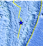
| Location | 19.971°S, 176.121°W |
| Depth | 236.9 km (147.2 miles) |
| Region | FIJI REGION |
| Distances | 160 km (99 miles) NW of NUKU`ALOFA, Tonga 267 km (165 miles) WSW of Neiafu, Tonga 279 km (173 miles) ENE of Ndoi Island, Fiji 2072 km (1287 miles) NNE of Auckland, New Zealand |
| Location Uncertainty | horizontal +/- 19.1 km (11.9 miles); depth +/- 7.6 km (4.7 miles) |
| Parameters | NST=185, Nph=210, Dmin=661.2 km, Rmss=0.62 sec, Gp= 40°, M-type=body wave magnitude (Mb), Version=A |
| Source |
|
| Event ID | usc0006zn3 |
- Did you feel it? Report shaking and damage at your location. You can also view a map displaying accumulated data from your report and others.
Earthquake Maps


Scientific & Technical Information
 Historic Moment Tensor Solutions
- Preliminary Earthquake Report
- U.S. Geological Survey, National Earthquake Information Center:
World Data Center for Seismology, Denver
