
Magnitude 6.4 - NEW IRELAND REGION, PAPUA NEW GUINEA
2011 November 28 12:26:48 UTC
Earthquake Details
- This event has been reviewed by a seismologist.
| Magnitude | 6.4 |
|---|---|
| Date-Time |
|
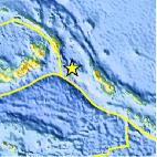
| Location | 5.532°S, 153.680°E |
| Depth | 50.4 km (31.3 miles) |
| Region | NEW IRELAND REGION, PAPUA NEW GUINEA |
| Distances | 137 km (85 miles) SSE of Taron, New Ireland, PNG 220 km (136 miles) WNW of Arawa, Bougainville, PNG 815 km (506 miles) WNW of HONIARA, Guadalcanal, Solomon Islands 2433 km (1511 miles) N of BRISBANE, Queensland, Australia |
| Location Uncertainty | horizontal +/- 12.4 km (7.7 miles); depth +/- 7.8 km (4.8 miles) |
| Parameters | NST=198, Nph=202, Dmin=223.8 km, Rmss=1.17 sec, Gp= 22°, M-type=regional moment magnitude (Mw), Version=6 |
| Source |
|
| Event ID | usc0006yv3 |
- Did you feel it? Report shaking and damage at your location. You can also view a map displaying accumulated data from your report and others.

Earthquake Maps


Scientific & Technical Information

 Tsunami Information
The earthquake locations and magnitudes cited in NOAA tsunami statements and bulletins are preliminary and are superseded by USGS locations and magnitudes computed using more extensive data sets.
General Tsunami Information
- Preliminary Earthquake Report
- U.S. Geological Survey, National Earthquake Information Center:
World Data Center for Seismology, Denver
