
Magnitude 4.9 - SOUTH OF THE FIJI ISLANDS
2011 November 28 01:44:17 UTC
Earthquake Details
- This event has been reviewed by a seismologist.
| Magnitude | 4.9 |
|---|---|
| Date-Time |
|
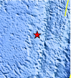
| Location | 24.647°S, 179.790°W |
| Depth | 506.8 km (314.9 miles) |
| Region | SOUTH OF THE FIJI ISLANDS |
| Distances | 456 km (283 miles) SSW of Ndoi Island, Fiji 544 km (338 miles) NNW of Raoul Island, Kermadec Islands 611 km (379 miles) SW of NUKU`ALOFA, Tonga 1451 km (901 miles) NNE of Auckland, New Zealand |
| Location Uncertainty | horizontal +/- 19.4 km (12.1 miles); depth +/- 6.9 km (4.3 miles) |
| Parameters | NST= 77, Nph= 80, Dmin=542.1 km, Rmss=1.43 sec, Gp=101°, M-type=body wave magnitude (Mb), Version=B |
| Source |
|
| Event ID | usc0006yp9 |
- Did you feel it? Report shaking and damage at your location. You can also view a map displaying accumulated data from your report and others.
Earthquake Maps


Scientific & Technical Information
 Historic Moment Tensor Solutions
- Preliminary Earthquake Report
- U.S. Geological Survey, National Earthquake Information Center:
World Data Center for Seismology, Denver
