
Magnitude 4.7 - BOUGAINVILLE REGION, PAPUA NEW GUINEA
2011 November 28 01:24:53 UTC
Earthquake Details
- This event has been reviewed by a seismologist.
| Magnitude | 4.7 |
|---|---|
| Date-Time |
|
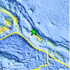
| Location | 5.689°S, 154.873°E |
| Depth | 146.3 km (90.9 miles) |
| Region | BOUGAINVILLE REGION, PAPUA NEW GUINEA |
| Distances | 95 km (59 miles) NW of Arawa, Bougainville, PNG 215 km (133 miles) WNW of Chirovanga, Choiseul, Solomon Islands 944 km (586 miles) ENE of PORT MORESBY, Papua New Guinea 2422 km (1504 miles) N of BRISBANE, Queensland, Australia |
| Location Uncertainty | horizontal +/- 25.5 km (15.8 miles); depth +/- 10.8 km (6.7 miles) |
| Parameters | NST= 24, Nph= 24, Dmin=945.1 km, Rmss=1.08 sec, Gp= 97°, M-type=body wave magnitude (Mb), Version=6 |
| Source |
|
| Event ID | usc0006yp5 |
- Did you feel it? Report shaking and damage at your location. You can also view a map displaying accumulated data from your report and others.

Earthquake Maps


Scientific & Technical Information
 Historic Moment Tensor Solutions
- Preliminary Earthquake Report
- U.S. Geological Survey, National Earthquake Information Center:
World Data Center for Seismology, Denver
