
Magnitude 5.3 - MOLUCCA SEA
2011 November 27 19:59:38 UTC
Earthquake Details
- This event has been reviewed by a seismologist.
| Magnitude | 5.3 |
|---|---|
| Date-Time |
|
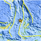
| Location | 2.030°N, 126.939°E |
| Depth | 25.3 km (15.7 miles) |
| Region | MOLUCCA SEA |
| Distances | 146 km (90 miles) NNW of Ternate, Moluccas, Indonesia 240 km (149 miles) ENE of Manado, Sulawesi, Indonesia 1023 km (635 miles) SW of KOROR, Palau 1537 km (955 miles) SSE of MANILA, Philippines |
| Location Uncertainty | horizontal +/- 15.7 km (9.8 miles); depth +/- 7.2 km (4.5 miles) |
| Parameters | NST=112, Nph=112, Dmin=574.4 km, Rmss=0.95 sec, Gp= 68°, M-type=body wave magnitude (Mb), Version=5 |
| Source |
|
| Event ID | usc0006ykv |
- Did you feel it? Report shaking and damage at your location. You can also view a map displaying accumulated data from your report and others.

Earthquake Maps


Scientific & Technical Information
 Historic Moment Tensor Solutions
 Tsunami Information
The earthquake locations and magnitudes cited in NOAA tsunami statements and bulletins are preliminary and are superseded by USGS locations and magnitudes computed using more extensive data sets.
General Tsunami Information
- Preliminary Earthquake Report
- U.S. Geological Survey, National Earthquake Information Center:
World Data Center for Seismology, Denver
