
Magnitude 5.1 - SANTA CRUZ ISLANDS
2011 November 27 17:48:02 UTC
Earthquake Details
- This event has been reviewed by a seismologist.
| Magnitude | 5.1 |
|---|---|
| Date-Time |
|
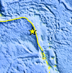
| Location | 12.495°S, 165.580°E |
| Depth | 54.9 km (34.1 miles) |
| Region | SANTA CRUZ ISLANDS |
| Distances | 199 km (123 miles) S of Lata, Santa Cruz Islands, Solomon Isl. 376 km (233 miles) NNW of Luganville, Espiritu Santo, Vanuatu 649 km (403 miles) NNW of PORT-VILA, Efate, Vanuatu 2115 km (1314 miles) NE of BRISBANE, Queensland, Australia |
| Location Uncertainty | horizontal +/- 19.4 km (12.1 miles); depth +/- 2.7 km (1.7 miles) |
| Parameters | NST= 78, Nph= 79, Dmin=702.4 km, Rmss=0.99 sec, Gp= 58°, M-type=body wave magnitude (Mb), Version=7 |
| Source |
|
| Event ID | usc0006yju |
- Did you feel it? Report shaking and damage at your location. You can also view a map displaying accumulated data from your report and others.
Earthquake Maps


Scientific & Technical Information
 Historic Moment Tensor Solutions
 Tsunami Information
The earthquake locations and magnitudes cited in NOAA tsunami statements and bulletins are preliminary and are superseded by USGS locations and magnitudes computed using more extensive data sets.
General Tsunami Information
- Preliminary Earthquake Report
- U.S. Geological Survey, National Earthquake Information Center:
World Data Center for Seismology, Denver
