
Magnitude 5.4 - NIAS REGION, INDONESIA
2011 November 27 11:01:05 UTC
Earthquake Details
- This event has been reviewed by a seismologist.
| Magnitude | 5.4 |
|---|---|
| Date-Time |
|
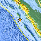
| Location | 0.157°N, 97.870°E |
| Depth | 17.9 km (11.1 miles) |
| Region | NIAS REGION, INDONESIA |
| Distances | 192 km (119 miles) SSW of Sibolga, Sumatra, Indonesia 196 km (121 miles) SW of Padangsidempuan, Sumatra, Indonesia 530 km (329 miles) SW of KUALA LUMPUR, Malaysia 1215 km (754 miles) NW of JAKARTA, Java, Indonesia |
| Location Uncertainty | horizontal +/- 12.5 km (7.8 miles); depth +/- 2 km (1.2 miles) |
| Parameters | NST=268, Nph=273, Dmin=303.9 km, Rmss=0.85 sec, Gp= 58°, M-type=teleseismic moment magnitude (Mw), Version=9 |
| Source |
|
| Event ID | usc0006ygx |
- Did you feel it? Report shaking and damage at your location. You can also view a map displaying accumulated data from your report and others.

Earthquake Maps


Scientific & Technical Information

 Tsunami Information
The earthquake locations and magnitudes cited in NOAA tsunami statements and bulletins are preliminary and are superseded by USGS locations and magnitudes computed using more extensive data sets.
General Tsunami Information
- Preliminary Earthquake Report
- U.S. Geological Survey, National Earthquake Information Center:
World Data Center for Seismology, Denver
