
Magnitude 4.9 - KERMADEC ISLANDS, NEW ZEALAND
2011 November 27 09:12:46 UTC
Earthquake Details
- This event has been reviewed by a seismologist.
| Magnitude | 4.9 |
|---|---|
| Date-Time |
|
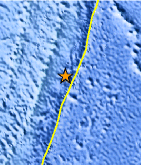
| Location | 30.776°S, 177.308°W |
| Depth | 10 km (6.2 miles) |
| Region | KERMADEC ISLANDS, NEW ZEALAND |
| Distances | 168 km (104 miles) ENE of L'Esperance Rock, Kermadec Islands 177 km (109 miles) SSE of Raoul Island, Kermadec Islands 996 km (618 miles) NE of Auckland, New Zealand 1089 km (676 miles) S of NUKU`ALOFA, Tonga |
| Location Uncertainty | horizontal +/- 20.5 km (12.7 miles); depth +/- 4 km (2.5 miles) |
| Parameters | NST=139, Nph=145, Dmin=180.3 km, Rmss=0.82 sec, Gp= 50°, M-type=body wave magnitude (Mb), Version=6 |
| Source |
|
| Event ID | usc0006ygb |
- Did you feel it? Report shaking and damage at your location. You can also view a map displaying accumulated data from your report and others.
Earthquake Maps


Scientific & Technical Information
 Historic Moment Tensor Solutions
 Tsunami Information
The earthquake locations and magnitudes cited in NOAA tsunami statements and bulletins are preliminary and are superseded by USGS locations and magnitudes computed using more extensive data sets.
General Tsunami Information
- Preliminary Earthquake Report
- U.S. Geological Survey, National Earthquake Information Center:
World Data Center for Seismology, Denver
