
Magnitude 4.8 - MINAHASA, SULAWESI, INDONESIA
2011 November 23 22:05:58 UTC
Earthquake Details
- This event has been reviewed by a seismologist.
| Magnitude | 4.8 |
|---|---|
| Date-Time |
|
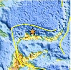
| Location | 1.419°N, 121.671°E |
| Depth | 24.9 km (15.5 miles) |
| Region | MINAHASA, SULAWESI, INDONESIA |
| Distances | 182 km (113 miles) WNW of Gorontalo, Sulawesi, Indonesia 209 km (129 miles) ENE of Palu, Sulawesi, Indonesia 842 km (523 miles) ESE of BANDAR SERI BEGAWAN, Brunei 1460 km (907 miles) S of MANILA, Philippines |
| Location Uncertainty | horizontal +/- 23.3 km (14.5 miles); depth +/- 12.1 km (7.5 miles) |
| Parameters | NST= 29, Nph= 29, Dmin=298.3 km, Rmss=1.11 sec, Gp=112°, M-type=body wave magnitude (Mb), Version=5 |
| Source |
|
| Event ID | usc0006x8l |
- Did you feel it? Report shaking and damage at your location. You can also view a map displaying accumulated data from your report and others.

Earthquake Maps


Scientific & Technical Information
 Historic Moment Tensor Solutions
- Preliminary Earthquake Report
- U.S. Geological Survey, National Earthquake Information Center:
World Data Center for Seismology, Denver
