
Magnitude 4.9 - TONGA REGION
2011 November 23 07:14:45 UTC
Earthquake Details
- This event has been reviewed by a seismologist.
| Magnitude | 4.9 |
|---|---|
| Date-Time |
|
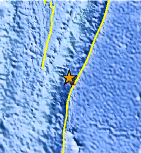
| Location | 23.141°S, 175.098°W |
| Depth | 32.7 km (20.3 miles) |
| Region | TONGA REGION |
| Distances | 222 km (137 miles) S of NUKU`ALOFA, Tonga 463 km (287 miles) SE of Ndoi Island, Fiji 510 km (316 miles) SSW of Neiafu, Tonga 1806 km (1122 miles) NE of Auckland, New Zealand |
| Location Uncertainty | horizontal +/- 19.8 km (12.3 miles); depth +/- 5.3 km (3.3 miles) |
| Parameters | NST= 54, Nph= 54, Dmin=733.6 km, Rmss=0.62 sec, Gp= 94°, M-type=body wave magnitude (Mb), Version=9 |
| Source |
|
| Event ID | usc0006wrw |
- Did you feel it? Report shaking and damage at your location. You can also view a map displaying accumulated data from your report and others.
Earthquake Maps


Scientific & Technical Information
 Historic Moment Tensor Solutions
- Preliminary Earthquake Report
- U.S. Geological Survey, National Earthquake Information Center:
World Data Center for Seismology, Denver
