
Magnitude 5.2 - KEPULAUAN MENTAWAI REGION, INDONESIA
2011 November 22 16:54:05 UTC
Earthquake Details
- This event has been reviewed by a seismologist.
| Magnitude | 5.2 |
|---|---|
| Date-Time |
|
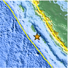
| Location | 2.320°S, 99.382°E |
| Depth | 23 km (14.3 miles) |
| Region | KEPULAUAN MENTAWAI REGION, INDONESIA |
| Distances | 179 km (111 miles) SW of Padang, Sumatra, Indonesia 359 km (223 miles) WNW of Bengkulu, Sumatra, Indonesia 632 km (392 miles) SW of SINGAPORE 930 km (577 miles) WNW of JAKARTA, Java, Indonesia |
| Location Uncertainty | horizontal +/- 10.8 km (6.7 miles); depth +/- 20.8 km (12.9 miles) |
| Parameters | NST= 88, Nph= 88, Dmin=345.9 km, Rmss=0.91 sec, Gp=130°, M-type=body wave magnitude (Mb), Version=A |
| Source |
|
| Event ID | usc0006w2j |
- Did you feel it? Report shaking and damage at your location. You can also view a map displaying accumulated data from your report and others.

Earthquake Maps


Scientific & Technical Information
 Historic Moment Tensor Solutions
 Tsunami Information
The earthquake locations and magnitudes cited in NOAA tsunami statements and bulletins are preliminary and are superseded by USGS locations and magnitudes computed using more extensive data sets.
General Tsunami Information
- Preliminary Earthquake Report
- U.S. Geological Survey, National Earthquake Information Center:
World Data Center for Seismology, Denver
