
Magnitude 5.1 - OFF EAST COAST OF THE NORTH ISLAND, N.Z.
2011 November 21 19:38:29 UTC
Earthquake Details
- This event has been reviewed by a seismologist.
| Magnitude | 5.1 |
|---|---|
| Date-Time |
|
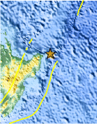
| Location | 37.584°S, 179.113°E |
| Depth | 2.5 km (1.6 miles) (poorly constrained) |
| Region | OFF EAST COAST OF THE NORTH ISLAND, N.Z. |
| Distances | 154 km (95 miles) NE of Gisborne, New Zealand 259 km (160 miles) ENE of Rotorua, New Zealand 393 km (244 miles) ESE of Auckland, New Zealand 556 km (345 miles) NE of WELLINGTON, New Zealand |
| Location Uncertainty | horizontal +/- 17.5 km (10.9 miles); depth +/- 7.7 km (4.8 miles) |
| Parameters | NST= 39, Nph= 39, Dmin=71.2 km, Rmss=1.19 sec, Gp= 97°, M-type=body wave magnitude (Mb), Version=6 |
| Source |
|
| Event ID | usc0006vji |
- Did you feel it? Report shaking and damage at your location. You can also view a map displaying accumulated data from your report and others.

Earthquake Maps


Scientific & Technical Information
 Historic Moment Tensor Solutions
Additional Information
- Preliminary Earthquake Report
- U.S. Geological Survey, National Earthquake Information Center:
World Data Center for Seismology, Denver
