
Magnitude 5.2 - NEW IRELAND REGION, PAPUA NEW GUINEA
2011 November 21 03:48:40 UTC
Earthquake Details
- This event has been reviewed by a seismologist.
| Magnitude | 5.2 |
|---|---|
| Date-Time |
|
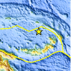
| Location | 3.591°S, 150.371°E |
| Depth | 37.2 km (23.1 miles) |
| Region | NEW IRELAND REGION, PAPUA NEW GUINEA |
| Distances | 105 km (65 miles) S of Kavieng, New Ireland, PNG 167 km (103 miles) WNW of Rabaul, New Britain, PNG 771 km (479 miles) NNE of PORT MORESBY, Papua New Guinea 2664 km (1655 miles) N of BRISBANE, Queensland, Australia |
| Location Uncertainty | horizontal +/- 24.1 km (15.0 miles); depth +/- 9.8 km (6.1 miles) |
| Parameters | NST= 64, Nph= 64, Dmin=>999 km, Rmss=0.86 sec, Gp=122°, M-type=body wave magnitude (Mb), Version=9 |
| Source |
|
| Event ID | usc0006vc0 |
- Did you feel it? Report shaking and damage at your location. You can also view a map displaying accumulated data from your report and others.

Earthquake Maps


Scientific & Technical Information
 Historic Moment Tensor Solutions
 Tsunami Information
The earthquake locations and magnitudes cited in NOAA tsunami statements and bulletins are preliminary and are superseded by USGS locations and magnitudes computed using more extensive data sets.
General Tsunami Information
- Preliminary Earthquake Report
- U.S. Geological Survey, National Earthquake Information Center:
World Data Center for Seismology, Denver
