
Magnitude 4.7 - PHILIPPINE ISLANDS REGION
2011 November 20 21:25:40 UTC
Earthquake Details
- This event has been reviewed by a seismologist.
| Magnitude | 4.7 |
|---|---|
| Date-Time |
|
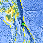
| Location | 5.617°N, 127.230°E |
| Depth | 81.3 km (50.5 miles) |
| Region | PHILIPPINE ISLANDS REGION |
| Distances | 234 km (145 miles) ESE of General Santos, Mindanao, Philippines 240 km (149 miles) SE of Davao, Mindanao, Philippines 825 km (512 miles) WSW of KOROR, Palau 1206 km (749 miles) SE of MANILA, Philippines |
| Location Uncertainty | horizontal +/- 24.9 km (15.5 miles); depth +/- 10.9 km (6.8 miles) |
| Parameters | NST= 30, Nph= 31, Dmin=243.8 km, Rmss=0.43 sec, Gp=148°, M-type=body wave magnitude (Mb), Version=5 |
| Source |
|
| Event ID | usc0006v94 |
- Did you feel it? Report shaking and damage at your location. You can also view a map displaying accumulated data from your report and others.
Earthquake Maps


Scientific & Technical Information
 Historic Moment Tensor Solutions
- Preliminary Earthquake Report
- U.S. Geological Survey, National Earthquake Information Center:
World Data Center for Seismology, Denver
