
Magnitude 4.7 - NORTH OF HALMAHERA, INDONESIA
2011 November 20 05:55:43 UTC
Earthquake Details
- This event has been reviewed by a seismologist.
| Magnitude | 4.7 |
|---|---|
| Date-Time |
|
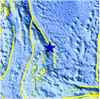
| Location | 3.131°N, 128.967°E |
| Depth | 175.3 km (108.9 miles) |
| Region | NORTH OF HALMAHERA, INDONESIA |
| Distances | 313 km (194 miles) NE of Ternate, Moluccas, Indonesia 492 km (305 miles) ENE of Manado, Sulawesi, Indonesia 769 km (477 miles) SW of KOROR, Palau 1543 km (958 miles) SE of MANILA, Philippines |
| Location Uncertainty | horizontal +/- 29.9 km (18.6 miles); depth +/- 17.6 km (10.9 miles) |
| Parameters | NST= 24, Nph= 24, Dmin=829.3 km, Rmss=0.91 sec, Gp=194°, M-type=body wave magnitude (Mb), Version=5 |
| Source |
|
| Event ID | usc0006v3t |
- Did you feel it? Report shaking and damage at your location. You can also view a map displaying accumulated data from your report and others.
Earthquake Maps


Scientific & Technical Information
 Historic Moment Tensor Solutions
- Preliminary Earthquake Report
- U.S. Geological Survey, National Earthquake Information Center:
World Data Center for Seismology, Denver
