
Magnitude 5.0 - KEPULAUAN BARAT DAYA, INDONESIA
2011 November 19 01:58:12 UTC
Earthquake Details
- This event has been reviewed by a seismologist.
| Magnitude | 5.0 |
|---|---|
| Date-Time |
|
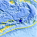
| Location | 7.490°S, 128.442°E |
| Depth | 152.3 km (94.6 miles) |
| Region | KEPULAUAN BARAT DAYA, INDONESIA |
| Distances | 321 km (199 miles) W of Saumlaki, Kepulauan Tanimbar, Indonesia 337 km (209 miles) ENE of DILI, Timor-Leste 420 km (260 miles) S of Ambon, Moluccas, Indonesia 610 km (379 miles) NNW of DARWIN, Northern Territory, Australia |
| Location Uncertainty | horizontal +/- 16.8 km (10.4 miles); depth +/- 9.1 km (5.7 miles) |
| Parameters | NST= 65, Nph= 66, Dmin=319.5 km, Rmss=0.84 sec, Gp= 61°, M-type=body wave magnitude (Mb), Version=5 |
| Source |
|
| Event ID | usc0006un8 |
- Did you feel it? Report shaking and damage at your location. You can also view a map displaying accumulated data from your report and others.

Earthquake Maps


Scientific & Technical Information
 Historic Moment Tensor Solutions
 Tsunami Information
The earthquake locations and magnitudes cited in NOAA tsunami statements and bulletins are preliminary and are superseded by USGS locations and magnitudes computed using more extensive data sets.
General Tsunami Information
- Preliminary Earthquake Report
- U.S. Geological Survey, National Earthquake Information Center:
World Data Center for Seismology, Denver
