
Magnitude 4.7 - SOUTH OF JAVA, INDONESIA
2011 November 18 12:23:50 UTC
Earthquake Details
- This event has been reviewed by a seismologist.
| Magnitude | 4.7 |
|---|---|
| Date-Time |
|
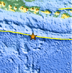
| Location | 11.040°S, 113.658°E |
| Depth | 14.7 km (9.1 miles) |
| Region | SOUTH OF JAVA, INDONESIA |
| Distances | 314 km (195 miles) SSW of Denpasar, Bali, Indonesia 317 km (196 miles) S of Jember, Java, Indonesia 357 km (221 miles) SSE of Malang, Java, Indonesia 924 km (574 miles) SE of JAKARTA, Java, Indonesia |
| Location Uncertainty | horizontal +/- 16 km (9.9 miles); depth +/- 8.7 km (5.4 miles) |
| Parameters | NST= 31, Nph= 35, Dmin=289.4 km, Rmss=1.17 sec, Gp=122°, M-type=body wave magnitude (Mb), Version=7 |
| Source |
|
| Event ID | usc0006u7c |
- Did you feel it? Report shaking and damage at your location. You can also view a map displaying accumulated data from your report and others.

Earthquake Maps


Scientific & Technical Information
 Historic Moment Tensor Solutions
- Preliminary Earthquake Report
- U.S. Geological Survey, National Earthquake Information Center:
World Data Center for Seismology, Denver
