
Magnitude 4.3 - MOLUCCA SEA
2011 November 18 10:54:19 UTC
Earthquake Details
- This event has been reviewed by a seismologist.
| Magnitude | 4.3 |
|---|---|
| Date-Time |
|
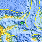
| Location | 0.277°S, 124.185°E |
| Depth | 81.5 km (50.6 miles) |
| Region | MOLUCCA SEA |
| Distances | 155 km (96 miles) SE of Gorontalo, Sulawesi, Indonesia 210 km (130 miles) SSW of Manado, Sulawesi, Indonesia 928 km (576 miles) N of DILI, Timor-Leste 1534 km (953 miles) NNW of DARWIN, Northern Territory, Australia |
| Location Uncertainty | horizontal +/- 24.8 km (15.4 miles); depth +/- 21.5 km (13.4 miles) |
| Parameters | NST= 17, Nph= 17, Dmin=178.1 km, Rmss=1.08 sec, Gp=119°, M-type=body wave magnitude (Mb), Version=5 |
| Source |
|
| Event ID | usc0006u60 |
- Did you feel it? Report shaking and damage at your location. You can also view a map displaying accumulated data from your report and others.

Earthquake Maps


Scientific & Technical Information
 Historic Moment Tensor Solutions
- Preliminary Earthquake Report
- U.S. Geological Survey, National Earthquake Information Center:
World Data Center for Seismology, Denver
