
Magnitude 5.7 - OFF EAST COAST OF THE NORTH ISLAND, N.Z.
2011 November 18 04:34:07 UTC
Earthquake Details
- This event has been reviewed by a seismologist.
| Magnitude | 5.7 |
|---|---|
| Date-Time |
|
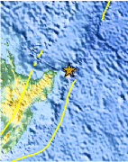
| Location | 37.586°S, 179.292°E |
| Depth | 20.1 km (12.5 miles) |
| Region | OFF EAST COAST OF THE NORTH ISLAND, N.Z. |
| Distances | 163 km (101 miles) NE of Gisborne, New Zealand 274 km (170 miles) ENE of Rotorua, New Zealand 409 km (254 miles) ESE of Auckland, New Zealand 565 km (351 miles) NE of WELLINGTON, New Zealand |
| Location Uncertainty | horizontal +/- 15.8 km (9.8 miles); depth +/- 5.1 km (3.2 miles) |
| Parameters | NST=108, Nph=113, Dmin=86.8 km, Rmss=1.38 sec, Gp= 47°, M-type=regional moment magnitude (Mw), Version=C |
| Source |
|
| Event ID | usc0006u0v |
- Did you feel it? Report shaking and damage at your location. You can also view a map displaying accumulated data from your report and others.

Earthquake Maps


Scientific & Technical Information

Additional Information
- Preliminary Earthquake Report
- U.S. Geological Survey, National Earthquake Information Center:
World Data Center for Seismology, Denver
