
Magnitude 5.2 - OFF EAST COAST OF THE NORTH ISLAND, N.Z.
2011 November 18 02:43:54 UTC
Earthquake Details
- This event has been reviewed by a seismologist.
| Magnitude | 5.2 |
|---|---|
| Date-Time |
|
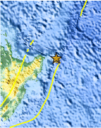
| Location | 37.763°S, 179.418°E |
| Depth | 18.4 km (11.4 miles) |
| Region | OFF EAST COAST OF THE NORTH ISLAND, N.Z. |
| Distances | 158 km (98 miles) NE of Gisborne, New Zealand 281 km (174 miles) E of Rotorua, New Zealand 424 km (263 miles) ESE of Auckland, New Zealand 559 km (347 miles) NE of WELLINGTON, New Zealand |
| Location Uncertainty | horizontal +/- 22.7 km (14.1 miles); depth +/- 8.9 km (5.5 miles) |
| Parameters | NST= 46, Nph= 59, Dmin=100.2 km, Rmss=1.47 sec, Gp= 68°, M-type=body wave magnitude (Mb), Version=B |
| Source |
|
| Event ID | usc0006tze |
- Did you feel it? Report shaking and damage at your location. You can also view a map displaying accumulated data from your report and others.

Earthquake Maps


Scientific & Technical Information
 Historic Moment Tensor Solutions
Additional Information
- Preliminary Earthquake Report
- U.S. Geological Survey, National Earthquake Information Center:
World Data Center for Seismology, Denver
