
Magnitude 4.7 - SOUTH OF THE FIJI ISLANDS
2011 November 15 17:41:44 UTC
Earthquake Details
- This event has been reviewed by a seismologist.
| Magnitude | 4.7 |
|---|---|
| Date-Time |
|
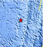
| Location | 24.527°S, 179.876°E |
| Depth | 510.7 km (317.3 miles) |
| Region | SOUTH OF THE FIJI ISLANDS |
| Distances | 453 km (281 miles) SSW of Ndoi Island, Fiji 569 km (353 miles) NNW of Raoul Island, Kermadec Islands 629 km (390 miles) SW of NUKU`ALOFA, Tonga 1452 km (902 miles) NNE of Auckland, New Zealand |
| Location Uncertainty | horizontal +/- 16.7 km (10.4 miles); depth +/- 8.7 km (5.4 miles) |
| Parameters | NST=163, Nph=165, Dmin=566.6 km, Rmss=0.95 sec, Gp= 76°, M-type=body wave magnitude (Mb), Version=7 |
| Source |
|
| Event ID | usc0006sd8 |
- Did you feel it? Report shaking and damage at your location. You can also view a map displaying accumulated data from your report and others.
Earthquake Maps


Scientific & Technical Information
 Historic Moment Tensor Solutions
- Preliminary Earthquake Report
- U.S. Geological Survey, National Earthquake Information Center:
World Data Center for Seismology, Denver
