
Magnitude 4.4 - TIMOR REGION
2011 November 14 13:20:14 UTC
Earthquake Details
- This event has been reviewed by a seismologist.
| Magnitude | 4.4 |
|---|---|
| Date-Time |
|
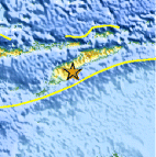
| Location | 9.697°S, 124.716°E |
| Depth | 26.3 km (16.3 miles) |
| Region | TIMOR REGION |
| Distances | 138 km (85 miles) ENE of Kupang, Timor, Indonesia 154 km (95 miles) SW of DILI, Timor-Leste 732 km (454 miles) WNW of DARWIN, Northern Territory, Australia 2013 km (1250 miles) ESE of JAKARTA, Java, Indonesia |
| Location Uncertainty | horizontal +/- 10.7 km (6.6 miles); depth +/- 17.9 km (11.1 miles) |
| Parameters | NST= 24, Nph= 24, Dmin=49.7 km, Rmss=1.34 sec, Gp= 61°, M-type=body wave magnitude (Mb), Version=4 |
| Source |
|
| Event ID | usc0006rq5 |
- Did you feel it? Report shaking and damage at your location. You can also view a map displaying accumulated data from your report and others.

Earthquake Maps


Scientific & Technical Information
 Historic Moment Tensor Solutions
- Preliminary Earthquake Report
- U.S. Geological Survey, National Earthquake Information Center:
World Data Center for Seismology, Denver
