
Magnitude 4.9 - BANDA SEA
2011 November 13 23:14:58 UTC
Earthquake Details
- This event has been reviewed by a seismologist.
| Magnitude | 4.9 |
|---|---|
| Date-Time |
|
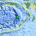
| Location | 5.799°S, 130.877°E |
| Depth | 120 km (74.6 miles) |
| Region | BANDA SEA |
| Distances | 242 km (150 miles) NNW of Saumlaki, Kepulauan Tanimbar, Indonesia 369 km (229 miles) W of Dobo, Kepulauan Aru, Indonesia 660 km (410 miles) ENE of DILI, Timor-Leste 737 km (457 miles) N of DARWIN, Northern Territory, Australia |
| Location Uncertainty | horizontal +/- 19.1 km (11.9 miles); depth +/- 16.6 km (10.3 miles) |
| Parameters | NST= 28, Nph= 32, Dmin=246 km, Rmss=0.66 sec, Gp= 79°, M-type=body wave magnitude (Mb), Version=4 |
| Source |
|
| Event ID | usc0006rkf |
- Did you feel it? Report shaking and damage at your location. You can also view a map displaying accumulated data from your report and others.

Earthquake Maps


Scientific & Technical Information
 Historic Moment Tensor Solutions
- Preliminary Earthquake Report
- U.S. Geological Survey, National Earthquake Information Center:
World Data Center for Seismology, Denver
