
Magnitude 4.7 - KERMADEC ISLANDS REGION
2011 November 13 14:43:49 UTC
Earthquake Details
- This event has been reviewed by a seismologist.
| Magnitude | 4.7 |
|---|---|
| Date-Time |
|
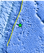
| Location | 31.837°S, 176.357°W |
| Depth | 82.3 km (51.1 miles) |
| Region | KERMADEC ISLANDS REGION |
| Distances | 245 km (152 miles) ESE of L'Esperance Rock, Kermadec Islands 321 km (199 miles) SSE of Raoul Island, Kermadec Islands 988 km (613 miles) ENE of Auckland, New Zealand 1191 km (740 miles) S of NUKU`ALOFA, Tonga |
| Location Uncertainty | horizontal +/- 40.1 km (24.9 miles); depth +/- 15.7 km (9.8 miles) |
| Parameters | NST= 19, Nph= 19, Dmin=323.6 km, Rmss=1.21 sec, Gp=212°, M-type=body wave magnitude (Mb), Version=7 |
| Source |
|
| Event ID | usc0006rd1 |
- Did you feel it? Report shaking and damage at your location. You can also view a map displaying accumulated data from your report and others.
Earthquake Maps


Scientific & Technical Information
 Historic Moment Tensor Solutions
- Preliminary Earthquake Report
- U.S. Geological Survey, National Earthquake Information Center:
World Data Center for Seismology, Denver
