
Magnitude 6.0 - NEW BRITAIN REGION, PAPUA NEW GUINEA
2011 October 18 05:05:05 UTC
Earthquake Details
- This event has been reviewed by a seismologist.
| Magnitude | 6.0 |
|---|---|
| Date-Time |
|
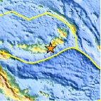
| Location | 5.872°S, 151.001°E |
| Depth | 21 km (13.0 miles) |
| Region | NEW BRITAIN REGION, PAPUA NEW GUINEA |
| Distances | 100 km (62 miles) ESE of Kimbe, New Britain, PNG 163 km (101 miles) ENE of Kandrian, New Britain, PNG 576 km (357 miles) NE of PORT MORESBY, Papua New Guinea 2401 km (1491 miles) N of BRISBANE, Queensland, Australia |
| Location Uncertainty | horizontal +/- 15 km (9.3 miles); depth +/- 5.2 km (3.2 miles) |
| Parameters | NST=342, Nph=347, Dmin=226 km, Rmss=0.99 sec, Gp= 29°, M-type="moment" magnitude from initial P wave (tsuboi method) (Mi/Mwp), Version=A |
| Source |
|
| Event ID | usc0006azz |
- Did you feel it? Report shaking and damage at your location. You can also view a map displaying accumulated data from your report and others.

Earthquake Maps


Scientific & Technical Information

 Tsunami Information
The earthquake locations and magnitudes cited in NOAA tsunami statements and bulletins are preliminary and are superseded by USGS locations and magnitudes computed using more extensive data sets.
General Tsunami Information
- Preliminary Earthquake Report
- U.S. Geological Survey, National Earthquake Information Center:
World Data Center for Seismology, Denver
