
Magnitude 4.9 - VANUATU REGION
2011 October 17 12:24:31 UTC
Earthquake Details
- This event has been reviewed by a seismologist.
| Magnitude | 4.9 |
|---|---|
| Date-Time |
|
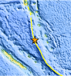
| Location | 19.276°S, 167.910°E |
| Depth | 25.7 km (16.0 miles) |
| Region | VANUATU REGION |
| Distances | 145 km (90 miles) WNW of Isangel, Tanna, Vanuatu 176 km (109 miles) SSW of PORT-VILA, Efate, Vanuatu 251 km (155 miles) N of Tadine, Loyalty Islands, New Caledonia 1772 km (1101 miles) ENE of BRISBANE, Queensland, Australia |
| Location Uncertainty | horizontal +/- 26.3 km (16.3 miles); depth +/- 8.1 km (5.0 miles) |
| Parameters | NST= 48, Nph= 48, Dmin=345.1 km, Rmss=0.37 sec, Gp= 97°, M-type=body wave magnitude (Mb), Version=2 |
| Source |
|
| Event ID | usc0006al8 |
- Did you feel it? Report shaking and damage at your location. You can also view a map displaying accumulated data from your report and others.
Earthquake Maps


Scientific & Technical Information
 Historic Moment Tensor Solutions
- Preliminary Earthquake Report
- U.S. Geological Survey, National Earthquake Information Center:
World Data Center for Seismology, Denver
