
Magnitude 4.5 - SOUTH OF SUMBA, INDONESIA
2011 October 13 12:16:33 UTC
Earthquake Details
- This event has been reviewed by a seismologist.
| Magnitude | 4.5 |
|---|---|
| Date-Time |
|
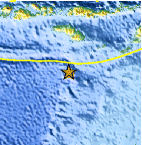
| Location | 12.000°S, 119.883°E |
| Depth | 10 km (6.2 miles) |
| Region | SOUTH OF SUMBA, INDONESIA |
| Distances | 263 km (163 miles) S of Waingapu, Sumba, Indonesia 400 km (248 miles) SSW of Ende, Flores, Indonesia 412 km (256 miles) SSE of Bima, Sumbawa, Indonesia 730 km (453 miles) WSW of DILI, Timor-Leste |
| Location Uncertainty | horizontal +/- 18 km (11.2 miles); depth +/- 2.8 km (1.7 miles) |
| Parameters | NST= 38, Nph= 39, Dmin=453.1 km, Rmss=1.64 sec, Gp= 54°, M-type=body wave magnitude (Mb), Version=4 |
| Source |
|
| Event ID | usc00068r4 |
- Did you feel it? Report shaking and damage at your location. You can also view a map displaying accumulated data from your report and others.

Earthquake Maps


Scientific & Technical Information
 Historic Moment Tensor Solutions
- Preliminary Earthquake Report
- U.S. Geological Survey, National Earthquake Information Center:
World Data Center for Seismology, Denver
