
Magnitude 4.8 - SOUTH OF THE FIJI ISLANDS
2011 October 12 03:00:47 UTC
Earthquake Details
- This event has been reviewed by a seismologist.
| Magnitude | 4.8 |
|---|---|
| Date-Time |
|
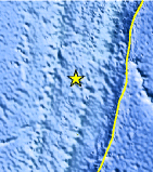
| Location | 26.731°S, 178.047°W |
| Depth | 56.7 km (35.2 miles) |
| Region | SOUTH OF THE FIJI ISLANDS |
| Distances | 281 km (174 miles) N of Raoul Island, Kermadec Islands 527 km (327 miles) N of L'Esperance Rock, Kermadec Islands 684 km (425 miles) SSW of NUKU`ALOFA, Tonga 1313 km (815 miles) NNE of Auckland, New Zealand |
| Location Uncertainty | horizontal +/- 23.3 km (14.5 miles); depth +/- 12.7 km (7.9 miles) |
| Parameters | NST= 45, Nph= 45, Dmin=>999 km, Rmss=0.49 sec, Gp= 79°, M-type=body wave magnitude (Mb), Version=5 |
| Source |
|
| Event ID | usc00067tv |
- Did you feel it? Report shaking and damage at your location. You can also view a map displaying accumulated data from your report and others.
Earthquake Maps


Scientific & Technical Information
 Historic Moment Tensor Solutions
- Preliminary Earthquake Report
- U.S. Geological Survey, National Earthquake Information Center:
World Data Center for Seismology, Denver
