
Magnitude 4.9 - SOUTH OF THE KERMADEC ISLANDS
2011 October 09 20:28:04 UTC
Earthquake Details
- This event has been reviewed by a seismologist.
| Magnitude | 4.9 |
|---|---|
| Date-Time |
|
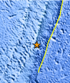
| Location | 32.418°S, 178.812°W |
| Depth | 26.1 km (16.2 miles) |
| Region | SOUTH OF THE KERMADEC ISLANDS |
| Distances | 109 km (67 miles) S of L'Esperance Rock, Kermadec Islands 360 km (223 miles) SSW of Raoul Island, Kermadec Islands 768 km (477 miles) NE of Auckland, New Zealand 1138 km (707 miles) NNE of WELLINGTON, New Zealand |
| Location Uncertainty | horizontal +/- 31.6 km (19.6 miles); depth +/- 11 km (6.8 miles) |
| Parameters | NST= 21, Nph= 21, Dmin=361.8 km, Rmss=0.82 sec, Gp=151°, M-type=body wave magnitude (Mb), Version=6 |
| Source |
|
| Event ID | usc00066qw |
- Did you feel it? Report shaking and damage at your location. You can also view a map displaying accumulated data from your report and others.
Earthquake Maps


Scientific & Technical Information
 Historic Moment Tensor Solutions
- Preliminary Earthquake Report
- U.S. Geological Survey, National Earthquake Information Center:
World Data Center for Seismology, Denver
