
Magnitude 4.7 - LUZON, PHILIPPINES
2011 October 09 13:25:36 UTC
Earthquake Details
- This event has been reviewed by a seismologist.
| Magnitude | 4.7 |
|---|---|
| Date-Time |
|
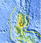
| Location | 16.521°N, 121.189°E |
| Depth | 45.7 km (28.4 miles) |
| Region | LUZON, PHILIPPINES |
| Distances | 64 km (39 miles) E of Baguio, Luzon, Philippines 102 km (63 miles) SW of Ilagan, Luzon, Philippines 104 km (64 miles) ENE of Dagupan, Luzon, Philippines 213 km (132 miles) N of MANILA, Philippines |
| Location Uncertainty | horizontal +/- 32.2 km (20.0 miles); depth +/- 7.4 km (4.6 miles) |
| Parameters | NST= 28, Nph= 28, Dmin=138 km, Rmss=0.62 sec, Gp=148°, M-type=body wave magnitude (Mb), Version=5 |
| Source |
|
| Event ID | usc00066ph |
- Did you feel it? Report shaking and damage at your location. You can also view a map displaying accumulated data from your report and others.

Earthquake Maps


Scientific & Technical Information
 Historic Moment Tensor Solutions
- Preliminary Earthquake Report
- U.S. Geological Survey, National Earthquake Information Center:
World Data Center for Seismology, Denver
